
 A series of storm systems is poised to bring unstable weather conditions to the area over the coming days. Forecasters are calling for multiple rounds of thunderstorms, with significant rainfall and an increased risk for severe weather events.
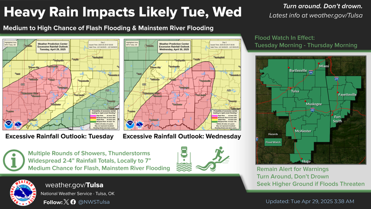
Rainfall Totals May Cause Flooding
Widespread rainfall amounts ranging from 2 to 7 inches are likely across the region, with the potential for even higher amounts in localized areas. This could result in flood-related concerns, especially from midweek into the weekend across southeastern Oklahoma and west-central Arkansas.
Strong Winds Anticipated Tuesday
A Wind Advisory is active for parts of eastern Oklahoma from Tuesday into Tuesday night. South winds between 20 and 30 mph, with gusts that could hit 45 mph, are expected to impact the area. These winds may create travel hazards and sporadic power outages.
Severe Weather Risk Begins Tonight
The chance for severe thunderstorms ramps up starting Tuesday evening and overnight. Forecast models indicate the possibility of:
Large to very large hail
Damaging wind gusts
Tornadoes, some of which could be strong or long-track
While isolated storms may arrive in eastern Oklahoma this evening, a broader wave of thunderstorms is forecast to develop later tonight and persist into Wednesday. These storms could remain severe, bringing threats of both wind and hail overnight.
Storm System Lingers Through Wednesday
Unsettled weather will stick around through Wednesday, with all severe weather types remaining on the table. Residents should prepare for another active day, with thunderstorms capable of producing flooding, hail, and tornadoes.
Safety Reminders
Stay tuned to local alerts and forecasts, and have a weather safety plan ready. Make sure you’re able to receive emergency warnings, especially overnight, and take action quickly if severe weather approaches.